Mulhacén Walkabout
22 - 28 Aug 2024
 The Mulhacén (3480m, in the Sierra Nevada) is the highest mountain on the Spanish mainland. It is only 59km as the crow flies from our finca to the Mulhacén. We hiked up there. And then Murielle fell ill...

A map should appear here soon...
𖣫 2800m All elevation gains added up were 2800m (not counting the 1250m ascent we made by bus)
Track
► Beneficio
► Cañar
► Soportújar
►Pampaneira
► Bubión
► Capileira
► ___ 🚌 ___
► Alto de Chorillo (2700m)
► Mulhacén (3480m)
► Río Mulhacén
► Pampaneira
► Órgiva
The Mulhacén (3480m, in the Sierra Nevada) is the highest mountain on the Spanish mainland. It is only 59km as the crow flies from our finca to the Mulhacén. We hiked up from Órgiva to Capileira, the last village before the high mountains, where we met 2 friends. Together we went 13km (1250m ascent) up by a public minibus and walked 5km (780m ascent) to the top of the Mulhacén.
Then we split up, Murielle and I wanted to continue hiking for several days through the Sierra Nevada and descend along the river Dílar near Granada. But Murielle fell ill and had to vomit several times. The cause could have been our drinking water. We had to change our plan, stayed up near the Mulhacén for a day and then descended straight back down to Capileira and Órgiva. Details can be found in the picture gallery. If you click on a photo, you can see it in better quality.
Preparation

View of our sun dryer: buckwheat sprouts, crackers made from buckwheat sprouts, wild plants, aloe vera and spices, figs
Thursday, 22 Aug 2024

Refreshment in a small water channel (acequia), close to Órgiva. There is another fellow hiker named Mar, but he doesn't want to be photographed.

Between the hippie village Beneficio and the village Cañar, we find a calm flat place to sleep.
Friday

We climb up a footpath to Cañar. There we see that the path is even signposted.

There appears to be a large bridge for the footpath across the river...

...But no, it's a dam to slow down the flow. Here we take a break on the dam and enjoy the view.

Mulberries before Pampaneira. However, not as many as we have found near Pitres in recent years.

Pampaneira and further up Bubión in sight.

We collect mulberries and figs as supplies for the next few days in the high mountains. Here in Pampaneira, we find lots of white dried mulberries under a mulberry tree.

Refresh in the Río Poqueira

There is a big waterfall, not far ftom Pampaneira.

We walk through Bubión and sleep just before Capileira. You can see the lights of Capileira in the background.
Saturday

Here you can see the church of Capileira in the background. We'll meet two friends nearby at 10.30am and take a public minibus 13km up into the mountains. So we have some time after getting up. And there are plenty of mulberries here!

Here we are with our two friends shortly after getting out of the minibus. Now we walk for 5km and climb 1250m.

If you click on the photo and zoom in, you'll see that three minibuses have even driven up. They wait here and take people back to Capileira at 6 pm.

The higher peak is the Pico del Veleta (3400m), the second highest mountain in the Sierra Nevada. Murielle and I actually wanted to go there too. But you'll soon see that something came up.

The stones get bigger, but there is a good path to the top.

Even up here, people were once shot at! A shooting bunker is hidden under these stones.

People on the moon

3480m - we are at the highest point of the Iberian Peninsula!

After our meal together, we split up again: our 3 friends go back to the minibus, Murielle and I want to delve deeper into the Sierra Nevada.
Watch video on youtube:

Passing clouds
On the way back to the bus, our friends pass clouds.

We need drinking water, and there's obviously a spring down there.

However, the water is stagnant and algalised, perhaps contaminated by excrement from grazing animals.

It looks clearer here and the odour is ok. I drink a little, Murielle a little more - probably a mistake...

Murielle is tired, we sleep here (in the background the Mulhacén) and with all the warm clothes we have, it is warm enough. But during the night, Murielle throws up and I also feel a bit sick to my stomach.
Sunday

Murielle still feels weak, has no appetite and doesn't want to move. We construct a sunshade and it's a good way to keep going.

But now we need good drinking water. I find a good source, but with dangerous access - see Drinking water at Mulhacén.
Monday

We slept another night in our little ‘cottage’. Murielle feels better now, we leave and continue hiking westwards.

"Laguna de la Caldera", the next lake near the Mulhacén, in the morning sun

Our path climbs and leads over this ridge, and later there are further ascents. Murielle feels weak and still has no appetite. We turn round...

...and we take the next downhill option. It is along the Río Mulhacén, the same river where we took the contaminated water.

I find the Mulhacén quite easy to hike barefoot. But here it is perfect: grass and large stones, no thistles, no thorns.

There are clouds below. I asked someone who has been up here several times before, whether he has ever seen the sea from here. He said he had even seen the mountains of Africa from here and that sometimes the view was very good.

Suddenly we see water in the river. We refresh ourselves and take some drinking water - we have no worries here.

A wonderfui break

We pass the refugio Poqueira. It is normally open, but is currently closed for renovation work. And we can see that the work is progressing.

3 pm, we are back at the river. It's raining a bit, but we find a comfortable spot under a bridge for a break.

The vegetation becomes denser. We always take the path closest to the Río Mulhacén. I think it's the most beautiful path, but not the easiest.

Sometimes the path is muddy. As a barefoot runner, I have an advantage here.

You also have to get over or around a few tree trunks.

The first fruit tree is an apple tree.

We spend the night under an oak tree. There's a thunderstorm up in the mountains.
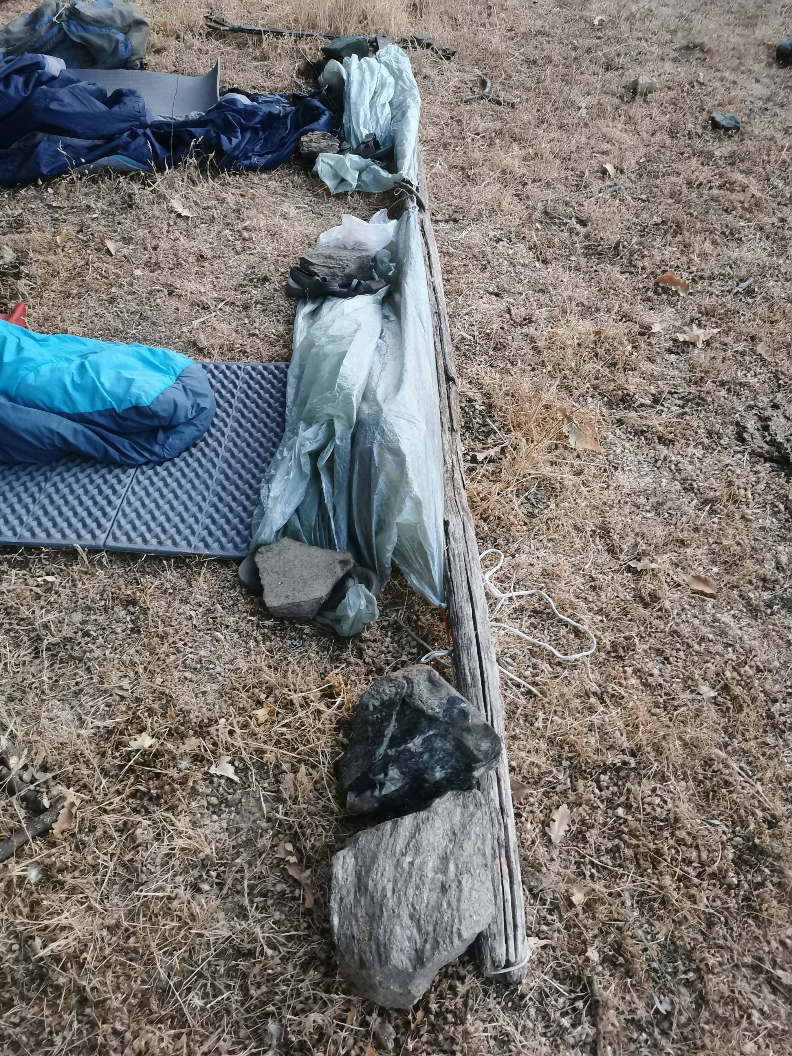
I therefore attach our tarps to the foot end so that we can simply pull them over us when it rains. But it stays dry.
Tuesday

We are over the clouds

Now we are under the clouds.

The first ripe figs

Mulberries

Peaches

Siesta, close to Pampaneira. It is still the same river, but it is called "Río Poqueira" here.

Sleeping place close to the GR-7. The area below us on the left is the flat roof of a house.
Wednesday

After hiking more than 50km barefoot, my feet have become sensitive. The calluses are rubbed off faster than they can grow back. I walk the remaining 7km in sandals.

What was that animal?

This time we take a route that doesn't take us through any more villages. We can see Soportújar, Cañar and Carataunas in the distance...

...and now Órgiva.

We collect and crack almonds to bring them home.

A 320m section of the route is barely recognisable as a path. It's hot and Murielle is tired.

We take a long siesta, bathe in the Guadalfeo river... and suddenly I see on the internet that we have a lift home. The driver is in a hurry, we run to the road and manage to meet him. He's a guitar maker and has a job to do in Málaga.
Take a look at the walkabouts to Mulhacén from 2012 and 2019!

Comments