River Discovery
27 - 30 Apr 2025
 Between the provinces of Málaga and Granada, there is a mountain range with few connecting roads. Sven and I tried a connection through a river...

A map should appear here soon...
𖣫 3000mAll elevation gains added up were about 3000m
Track
► El Cielo (1510m)
► Río Verde
► El Cielo
► Nerja-Maro
I invited to a "Spectacular River Walkabout". But the first river was already so spectacular that we soon had enough. I plan to repeat the "Spectacular River Walkabout" at a later date.
Sunday, 27 Apr 2025

In the background you can see part of the village of Maro, where we started our hike at 4 pm. We climb into the mountains on a ridge near the Cueva de Nerja.

In the afternoon I filled this container with a puree of sprouted chickpeas, vegetables and wild herbs, and a few hours later it was already overflowing. The reason for this is fermentation, which makes the meal even easier to digest. I had put the container in a plastic bag as a precaution.
Monday

We spent the night in an abandoned finca in the mountains.

We reach El Cielo (‘The Sky’, 1510m). The wind is strong.

There is a sheltered spot where we can lie down and enjoy the sun.

On the back of the mountain there is a ridge that soon takes us a little higher.

Cairns mark the path, and for a few years now it has also been available on mapy.cz. Both are very helpful for us.

Break with a view to the east. You can recognise the bays of La Herradura and Almuñécar.

We have left the marked path. First we walked eastwards along a ridge, and here we came to a dry riverbed. I had chosen this route at home based on the satellite images.

Slopes are difficult to recognise on the satellite images. But so far it has been quite easy, with little vegetation and few bumps.

But suddenly there is nowhere to go: a deep vertical slope, a deep dried-up waterfall.

We look at the landscape and surmise a former path on the slope. It cannot be recognised from this photo...

...but if you click on this photo and zoom in, you will recognise a wall of natural stones on the right, a clear indication of a former path. This gives us courage, because we have already seen at other waterfalls (in the Río Chillar and Río Higuerón) that there are old paths to bypass the waterfalls.

We find the path very easy and close.

We soon reach the natural stone wall that we saw from the waterfall. Sven thinks the path is so wide and elaborately constructed that it must have served more than just to bridge the waterfall. The path probably continued even further.

However, the path becomes more and more overgrown and we are happy that we are soon in the riverbed under the waterfall.

However, there's another dry waterfall. We don't see a bypass here, but we find it's possible to climb down the slope. Sven is a bit careless, slips, and falls into the puddle, which you can see in the photo if you click on it and zoom in. Sven lies down in the sun and dries his clothes, while I take my time climbing down safely.

We spend the night near the river, I climb up a bit and sleep here on the rock.
Tuesday

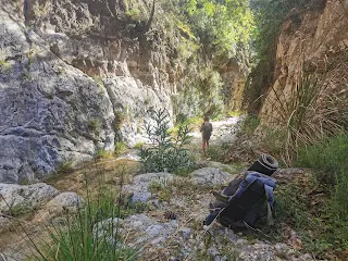
The river now has plenty of water, we often have to walk through the water or along the bank, where there are sometimes bushes.

A beautiful parasitic flower

We reach Río Verde, a tourist area where the paths are well developed.

Several times the path leads over large stones across the river.

There is even a suspension bridge here.

This viewing platform is only accessible via small paths. Its construction was certainly quite complex.

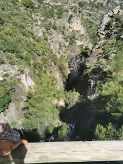
Behind the railing it goes down deep.

There are many pools and small waterfalls with crystal clear water.

You can't get on here without getting your feet wet.

Another suspension bridge

View from the suspension bridge down

We think it should be okay to drink from the river, since there's no civilization or agriculture here. But we meet a group leader who shows us a spring.

It looks a bit like a peeing dog that has obviously drunk a lot of water.

Sven explains to me that he needs a few days alone, even though he really enjoyed the hike. So we go our separate ways home.

The limestone of the river has glued many stones together like concrete.

The Rio Verde is a paradise for climbing enthusiasts.

There is a warning here that if you climb into the riverbed without equipment you may not be able to get back and may need to be rescued.

I am amazed at how much water comes out of this mountain.

The water has created many small pools.

Later, it dawns on me: This lake is higher than the mountain and probably supplies the mountain with water.

Looking back at the Rio Verde valley. If you click and zoom in on the photo, you can see a firebreak at the top of the ridge: a compromise to prevent forest fires from spreading beyond the firebreak.

A firebreak nearby, i.e. a wide strip from which all vegetation is removed.

I turn onto a small path that we missed on the hike in July 2022.

I climb higher and higher, and the sky clears. I hope to find a cave or some other warm place to spend the night.

The best spot I can find is here, sheltered from the wind in the bushes.

I collect stones that have been lying in the sun and pile them next to the sleeping area, place dry grass under the sleeping mat, put on all my clothes, and wrap my tarp around my sleeping bag. Still, I sometimes have to warm myself up by moving around during the night.
Wednesday

Chickweed grows next to the sleeping area, which I add to my breakfast.

However, the flowers of the bushes are poisonous. It is a species of broom.

I'm coming up from the path on the lower right. This is the transition from the province of Granada to the province of Malaga, and there's no path connecting here either. But I find a good, walkable connection across this slope.

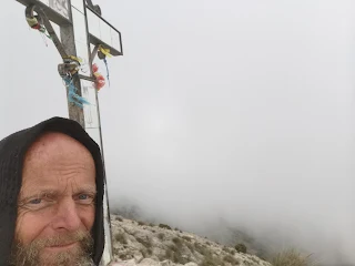
I'm back on El Cielo. There's only a little wind now, but the view isn't great either: I'm stuck in the clouds.

As I descended, the clouds had cleared. Now I am happy to get to this spring, as I hadn't any drinking water for a few hours. I still had some dried buckwheat sprouts and chickweed to eat. I arrive home in the evening.

Comments